


PCT Week Two
Crater Lake to Shelter Cove Resort
07/14 to 07/20
It is strange to be at Mazama Village and still so far from Crater Lake. 7.0 miles. In a car, seven miles is a few minutes, but on foot with a fully loaded pack, it is nearly three hours of walking!

On the 13th, we left Mazama and took the Annie Spring Trail, which rises sharply up from Mazama Village to reconnect with the PCT. We had 7 days of food and supplies on us, but we were amazed as we climbed, how much stronger we were after even a week.
We had failed to put any extra Deet in our resupply. Suddenly, as the mosquitoes began to buzz, we realized that we hadn't purchased any either. I dropped my pack and ran back while Kirk, and his blistered feet, waited. I paid $14 for a small can of Lemon Eucalyptus Insect Repellent in an aerosol can because that is all they had. Deet is gross. It smells, feels disgusting, tastes terrible (because no matter how hard you try, it will end up in your mouth!) Despite what the EPA says, it just can't be good for humans. However, if it had helped, we would have bathed in it. Put the toughest person in a box filled with blood thirsty mosquitoes and they would give up anything to get out. Well, the Deet didn't work, the $14 lemon stuff didn't work. We would most often use it while we were setting up or tearing down our tent. I would hose us both down and then fan Kirk while he unpacked the poles and pulled out the tent. The worst is bending over to do something while an aggressive angry mob attacks your face. The rest of the time, we just run.
We bought Kirk a long-sleeved shirt which was heavy and hot but would armor him somewhat from the bugs. As we hiked a dozen or more mosquitoes would line up on his right shoulder to hang out. Just ride there. We still didn't have pants, but I would shout out body parts like, "left lower leg" and Kirk would swipe the mosquitoes off that area.

We stayed on the PCT for several miles before cutting over. We took the Lightening Spring Trail to the Rim Trail and Crater Lake. From looking at the map, we calculated that the Lightening Spring Trail was a couple miles, but as it went on and on, we realized that it was much longer. (I just looked it up. It is 8.4 miles. The difference between an hour of hiking and four hours.)
We finally made it to Lightening Spring, which is the last water source for over 26 miles! We filled every container we had, since we wouldn't see water for two days. Water is heavy. We lean toward carrying more water, while some people are always on the brink of running out. We like to cook at night and drink without rationing during the day. We had some close calls.
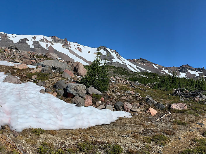
From Lightening Spring, we still had 0.8 miles to go before we hit the highway around the lake. We went through some pumice meadow and climbed 300 feet. We were too hot and grouchy to take pictures.
At last, we stepped out onto Rim Drive, crossed the road and drank in our first view of Crater Lake!

Pictures do not even come close to doing it justice. I certainly don't have the words to express the beauty of the lake. It is something that everyone must see for themselves.
The Rim Trail around the Watchman was closed due to snow. We heard of a couple of hikers that went through anyway, intrepid types who had sailed through the Sierras when everyone was flipping north, but we weren't that brave. We walked up the road, which was dangerous enough with all the vehicles flying by us.
The Rim Drive circles Crater Lake, but much of the time, the lake is obscured behind the caldera. Then the road breaks out into open areas and the lake is on full display. At the overlooks, mobs of tourist stop to take photos. Perhaps, due to our week of solitude, we felt like we had stepped into a madhouse of people jostling each other for the "perfect shot" but no one seemed to be looking at the lake.
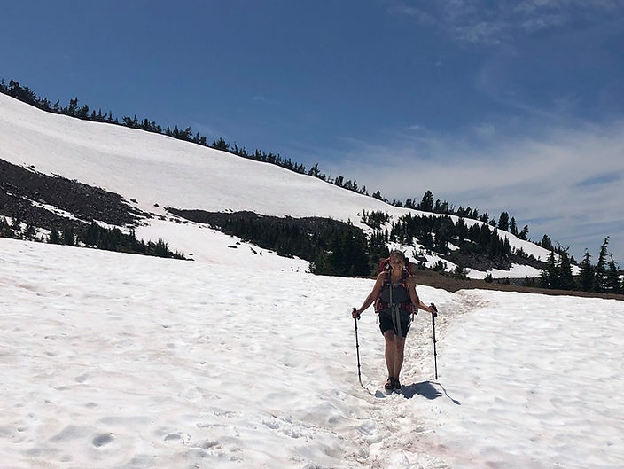
We hiked away from the crowds, around Hillman Peak and through the longest snowfields we had yet encountered. I was still hiking in my sandals due to the mystery rash on my ankles and it was a cold and slippery trek for me.

Once we rounded the peak, we were alone, away from the chaos of tourists, the car clubs, screaming children, the bikers. We had the rim all to ourselves. We sat in the silence and soaked in the purity, the quiet, the hypnotic beauty. We wanted to stay longer, but we had to press on to get to Grouse Hill where we would meet up with the PCT.
We had planned to dry camp there. We ran into other PCT hikers and began to hear rumors of a water cache at Highway 209. If true, we would cut down the dry miles from 26 to 17. Is it ironic that we were staring at the deepest, most pure water in North America and we were thirsty from rationing to get to our next source?

We left our perch and hiked back into the fray. At Merriam Point, at the North Junction of Rim Drive, the air had a carnival feel. People were driving by in convertibles, trailing music behind, others were posing with a White Bark Pine on a point of land that jutted out over the lake. A VW Bus flashed by, the inhabitants waving cheerfully at us with our big packs and well-worn clothes. I raised my trekking pole in a salute and had a flash of what it was like to bum around in the era of peace and love.
We left the lake and headed north through open plains and groves of trees. We were hurrying to stay ahead of a man and his son. Leap frogging is annoying and a great motivator. Even so, we swapped places with them a couple times, once when we stopped to put on our long sleeves. We had had a beautiful mosquito-less time on the rim, but as soon as we moved away, the little buggers were back.
We hiked to the highway and found a giant bear box full of 2.5-gallon water bottles. I stood swatting mosquitoes from around Kirk while he filled our water, and occupied with this, I thought about taking a picture of the amazing trail magic of water, but I just didn't. Bless those angels who put it there!

The next morning, we hit the trail early. The terrain was flat and view-less. We knew from our guidebook that we were passing the Pumice Desert, but we couldn't make it out through the Lodgepole pines. Later, during our next climb, we looked back and saw the five plus acre area of flat brown desolation, surrounded by green trees.
We were flying again. Just putting our heads down and digging in for speed to make it through the horrible plague of angry bugs. We crossed highway 138 about ten o'clock and found another water cache at a dirt road just beyond that. We were still well-watered, so we didn't stop. Soon after, we realized that we were, if not mosquito free, at least mostly free, so we stopped for lunch while we could. We attracted a family of Grey Jays. The babies were almost adults, but still a bit scraggly. They hopped all over beside us, eating our crumbs and begging for more.

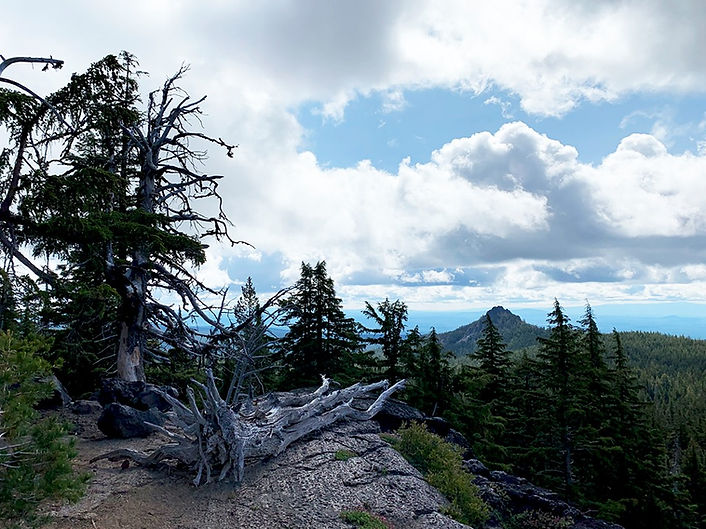
Soon after our stop, we began to climb Mt. Thielsen and we saw the caldera in the distance, hardly believing that we had just been there the previous day. Looking back and seeing how far one has come is the most satisfying sensation for a hiker.

From the high point where the PCT met Mt. Thielsen trail, we found a man-made rock enclosure with our first cell service since the weak Wi-Fi at Mazama Village. It was cold and windy, but we needed to make some phone calls and update our status on Facebook.

Mt. Thielsen became one of my favorite mountains on the trail for its rugged spire-like summit. The mountain is 9,184 feet tall. The PCT is 7,334’ at that point and as we hiked down the north side of the mountain, we hit more snow.
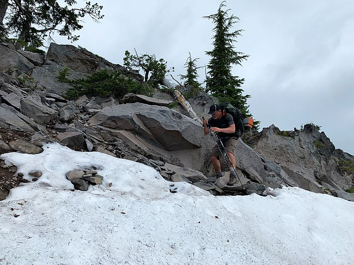
We hiked over a substantial amount of snow during our adventure, but we only encountered a couple places where one slip meant death. Here on Thielsen, one slip would mean pain, perhaps something broken, and a horrendous climb to regain the trail, so we were as careful as we could be.

After the 26-mile dry stretch of trail, we arrived at Thielsen Creek, which was winter postcard perfect. It was cold camping on the north side of Thielsen and the clouds that set in as we were hiking around from the south, thickened. We were socked in except for a brief blue spot the following morning as we prepared to leave. The water, flowing from under the snow, burned my fingers with its icy cold as I rinsed out some socks.

We camped just up from the creek where we met a nice couple heading south. It is always nice to meet people who have been over the trail ahead and can give advice and knowledge.
After we re-hydrated vegetables and mixed them with Ramen, I began to journal about our Crater Lake experience. Two steady, repetitive sounds began. One long sharp blast, like the whistle of a traffic cop answered by a lower foghorn. This went on for hours with machine-like regularity. We were so far from anywhere that we felt we must be hearing a bird.
I have since Googled for an explanation and found that the Buff-spotted Flufftail makes a foghorn sound, but it lives in places like Botswana, Cameroon, Ethiopia, Tanzania, and Zimbabwe.
The mystery stands.

After Thielsen, we climbed slowly, continuing through porous, dry terrain toward the Oregon/Washington high point. If we stayed on the trail, and did not deviate, we would have over thirty-three miles without a water source.

We reached the Oregon/Washington high point of the Pacific Crest Trail at 9 a.m. on the 16th where the sign marks the elevation as 7, 560 feet. My GPS puts it at 7, 573. The GPS is probably more accurate than the older surveys, but either way, we wondered how this place could be the highest spot. We had climbed hard over Mt. Thielsen and back down again and we didn't feel that we had climbed much at all to get to the high point.
We descended to the cliff view!

As usual, our day was dictated by water. We had planned to go to Six Horse Spring and then hike the steep mile down to the water. But we passed hikers who assured us that the water cache at Windigo Pass was full. It is always nerve wracking to pass perfectly good water sources to rely on a cache. What if, always creeps into the back of one's mind. We went back and forth on it, but we didn't want to hike back up that steep path from the spring with all that water. We pressed on the six plus miles to the pass.
It took a little over two and a half hours to cover the six miles. We tried not to worry about water as we wound down through the forest. Unspeakable relief filled us when we saw those big plastic bottles on the side of the road. After Windigo Pass we did not encounter any other water cashes on the trail despite more long, dry stretches.
Trails angels had also left mosquito repellent wipes, but all the boxes were empty. We quickly set up our tent and dove inside to hide from the angry and aggressive bugs. Wikipedia says that the word "mosquito" is Spanish for "little fly". That almost sounds cute! But it also states that because the mosquito is a great transmitter of disease, they kill more people than any other animal.

We cooked, with the stove outside the tent, reaching one arm out of a small hole we made in the door. We lay back and tried to relax. Once again, we were discouraged by the bugs that camped out on the netting of our tent, just waiting for one of us to crack the zipper. We were tired after our 21.7-mile day; we were irritable. The tent and all our possessions were filthy. And the mosquito hell had begun again.
A bee joined them, crawling around adding his voice to theirs. A mosquito kept bumping into the bee in a frenzied attempt to find entrance into our dirty sanctuary. Suddenly, the bee turned on the mosquito, grabbed it with his legs, shook it, bit it and then broke it and threw it aside like a worthless piece of trash.
We cheered.
We woke up the next day in the silence. No angry buzzing. But the moment I stepped out of the tent, the mosquitoes attacked, en masse and as angry as ever. We hiked hard to get away from Windigo, thrilled to be climbing. We did not entirely escape the mosquitoes, but they thinned down so that we could enjoy the views back toward Mt. Thielsen, now just a sharp peak in the distance.

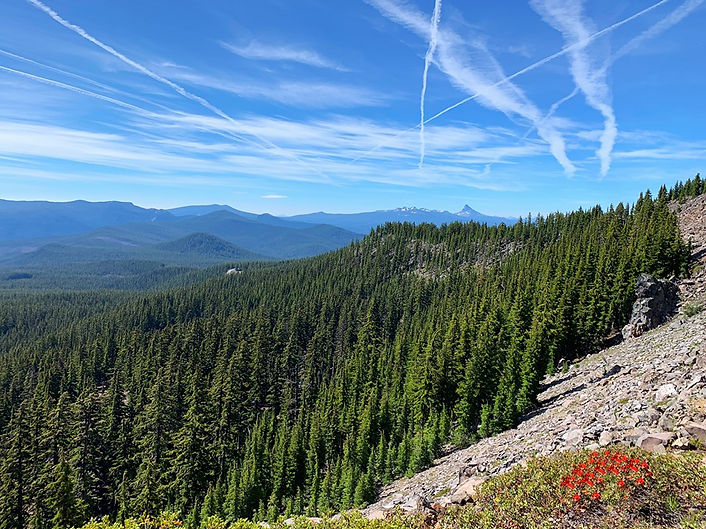
We had a lovely view ahead to Cow Horn Mountain.

We wore our shirts on our heads and said that we didn't really want mosquito netting like so many hikers that we saw, postulating that it would be hot and claustrophobic over our faces. (This is something that people who don't have netting say to make themselves feel better!)
We crossed more snow and suddenly, Kirk spotted a perfect footprint in the snow 18"-24" long and about 6"-8" wide! Unfortunately, the print was at an angle and difficult to get to. He slid down the snow to get the shot, but he couldn’t get a good perspective, so there was no way to prove the size of the “Big Foot.”
We hiked a pretty easy 12.1 ending our day at the beautiful, serene Summit Lake with a lovely glimpse of Diamond Peak in the distance.
As we looked for a campsite, we saw another hiker, whom we had seen sleeping at the junction to Six Horse Spring the previous day. She was sitting in the middle of the Forest Road that circled the west side of the lake, the contents of her backpack spilled onto the gravel. She must have had a couple dozen candy bars, if not more. We tried not to stare at the pile as we talked with her. I was searching my brain to see if I could remember etiquette for this situation. Could I offer to buy one of them? We were low on food, just enough to get us to Shelter Cove the next day. We didn’t have anything good left. And here she sat, this tiny person, with so much candy! I couldn't think of a way to broach the subject, so we pulled ourselves away. (I ended up calling her Candy Elf, although her real trail name had to do with socks.)
We found a campsite with a picnic table, near the one and only vault toilet and set up camp. It was at the end of a turnaround and many cars pulled in and then out again, disappointed that the prime spot was taken up by hikers, I'm sure.
Two amazing things came out of our stay at Summit Lake. I met another hiker who said that her friend was meeting her at Shelter Cove and that she would ask him to bring us head nets!
We also met Eric and Gretchen Tolstoy and their dog Nadia. They were out and about celebrating their wedding anniversary. They asked us lots of questions about our hike. We were always happy to share our experiences. They offered us graham crackers and a Hershey's chocolate bar. I think they offered us more, but I didn't want to seem like a pig. I refused the second candy bar and regretted that later. I wanted to ask for a drink. We were half dehydrated all the time and ready to trade in water for something a little more flavorful. Then Gretchen asked if we needed anything else, so I jumped through that door and asked for a soda. (This, sly begging for food is called yogi-ing in the hiker world. This is my one and only experience doing this, and I was thrilled and ashamed of myself.) Gretchen said she had flavored soda water, tangerine! She gave me two. Her husband shared his Sharp’s with Kirk. He gave Kirk two of those.
They were our first trail angels. We were the first time they had trail angel-ed!

Our first ever trail magic!

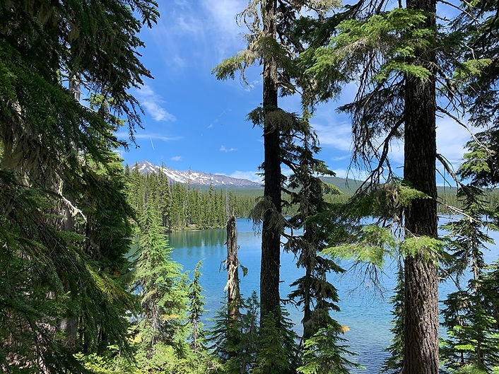
We fell asleep to this view!

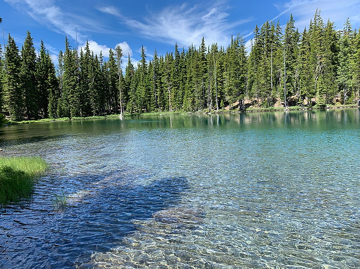
We woke up to this view!
We climbed from Summit Lake to Diamond Peak. We had spotted Diamond Peak several times over the last few days, its long slouching body sprawled out like a sunning cat. We kept waiting to be awed by it, but we thought it anticlimactic after some of our other views. Perhaps if the mosquitoes had thinned, we would have enjoyed the beauty a little more, but they attacked with renewed vigor when we tried to stop and eat a snack.

Fog rolled in and receded several times while we ate our Cliff bar and swatted at the bugs. Once again, we heard the high-pitched police whistle and the low mournful foghorn in answer. I started to speculate that the sounds had to do with the lakes and weren't birds at all. I assume that when the answer comes, perhaps from one of you, we will feel foolish in our speculations.

We crossed more snow fields, the reflection blinding in intensity. I couldn't open my eyes at all. I dropped my pack and dug out my sunglasses. Dropping one's pack feels good, but it is also a big inconvenience and seems like a colossal waste of time when the miles stretch out. Especially when a resort awaits at the end of those miles.

Diamond Peak didn't impress us as much as the descent to Shelter Cove. The snowfields grew smaller and the ponds more plentiful with their mirror surfaces reflecting the perfect trees and sky. Water ran in rivers down the trail which was a deep groove between muddy banks. So much snow melt. Perhaps the ponds held a special appeal to us because we had been thirsty in the dry for so long with water sources so few and far between.

As we drew near to Odell Lake and Shelter Cove Resort, we spotted Pacific Rhododendron along the trail. It cheered me. I felt like we were getting close to our native hiking grounds.
We also spotted a shirtless guy pushing his overgrown mountain bike up the steep trail. Bikes are prohibited on the Pacific Crest Trail. It is open to hikers and equestrians. Every trail head is clearly marked.
The guy had bleach-blonde hair and gym muscles. Everything about his seemed fake and manicured. He was complaining about the horse manure on the trail. How could "they" allow it? Also, he wanted to know how the mosquitoes were up ahead. We didn’t tell him that he would need a shirt in his near future. He would find out soon enough for himself. We just hoped that he wouldn't run us down if he decided to turn around before we left the trail.

We arrived at Shelter Cove a little before 2 p.m. in the afternoon. This was our second resupply point and as with our first, the cashier had trouble locating our box. I mentioned that my tracking info indicated that the package had been delivered several days before. This seemed to make her angry. She found our box but charged us double what she charged the couple in front of us for our campsite. We asked her about it, and she explained that they had sent their package USPS which cost a lot more and because they chose to do this, she was giving them a break on their campsite.
Ok?!?!?!

Despite the rough start, we had an amazing time at Shelter Cove. We took a zero there, that is zero miles that day, a much-needed rest from the trail. We did laundry and showered in their cozy little private shower rooms with fresh towels, as many as you want, and free liquid soap. We ate and ate. We met other hikers and ate some more. We sat at a picnic table by the lake much of the day and basked in the sun.
We noticed that being inside wasn’t attractive to us. We browsed the camp store in short bursts, which had a decent selection of food and drink as well as medical supplies and tourist trinkets for the campers. I loved the trinkets and would have bought stuff. But of course, when you are carrying everything on your back, you watch what you buy. From then on, I made sure that I had a cache of candy. Maybe not as much as Candy Elf, but something high-cal and sweet for each day.

PCT hikers are an eclectic group. We met people older than we are and people younger than our kids. We met Germans, Australians. Norwegians, people from all over the United States. We saw a young woman from Germany who stood maybe about five feet tall. She had hiked through the Sierras when most people were flipping north and then hiking south to get away from the deep snow. They hoped to hit the mountains after snow melt.
There is a lot of rivalry between Nobo (northbound hikers) and Sobo (southbound). There's a lot of silly debate about what constitutes a thru hiker, such as, if you have to get off the trail for fire or snow or any reason and you return a year or two later, are you a thru hiker? I am not going to add my opinion to the enormous word count on Facebook and other social media outlets on the subject. What do I know? I am just a section hiker anyway.
At Shelter Cove, we met Sobo and Nobo hikers who were all very nice to us. The farther north we went, the hotter the debate and the more prejudice we encountered, some of it blatant and rude, since we were only hiking Oregon.
We met up with the hiker who had promised us head nets and she delivered! We can never thank her enough for that. She is an absolute angel. It's a small world. She works a block away from the post office where Kirk works!

Shelter Cove had a tent set up for PCT hikers with tables and a microwave as well as outlets for charging phones. (We had a solar panel that Kirk wore on his pack during the day, charging a power pack that then charged our phones at night. It weighed a pound, but kept both our phones going the entire time, so we didn't have to fight for outlets.)
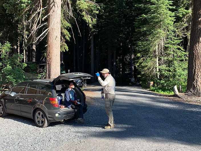
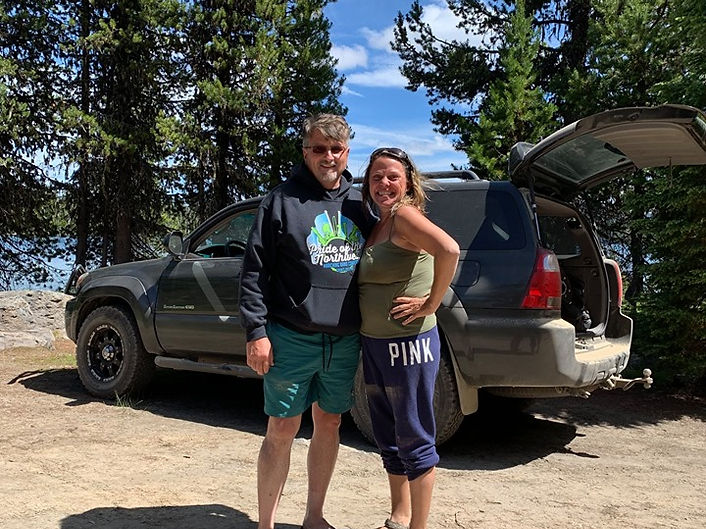
We met an awesome guy named Dale (on the right) and spent a lot of our zero hanging out with him. We made plans to hike with him, but the timing just didn't work out. He was finishing his thru hike that he started a few years before but had to abandon for various reasons. He has now completed the hike! He has a great blog where he shares his story.
The guy in the car had a big box of Snickers that he handed out to all the hikers. I didn't find out what his inspired him to do that, but I can tell you this, Snickers are always appreciated.
After a day and a half at Shelter Cove, we were ready to get back out there. We had one week left until Big Lake Youth Camp where Kinley and Ian were going to bring my Beagle. I missed him so much. He and I have hiked together for six years and up to this point I had never backpacked without him. He has intense separation anxiety and I knew that he would spend most of his days staring out the window, watching for my return. But we had some rough terrain to cross before he could join us.
Still every day, I shouted into the trees, "Misha, I am coming!"
"In the end, it's not the years in your life that count. It's the life in your years."
Abraham Lincoln